
Old Maps showing Newgrange and Knowth
These Ordnance Survey Maps were produced in 1837, Newgrange and Knowth are both referred to as Moats. In a later handwritten alteration Newgrange is referred to as a Tumulus.
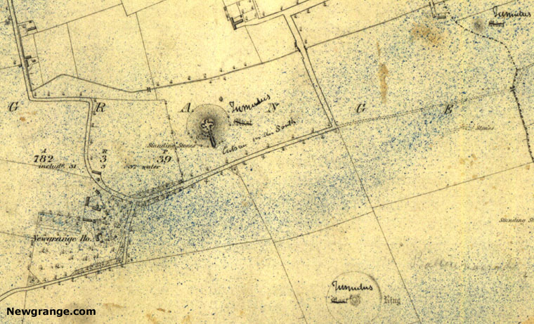 Newgrange showing the internal passage and chamber on a map dated 1837
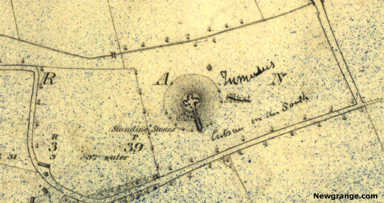 Close up of Newgrange showing the Standing Stones on a map dated 1837
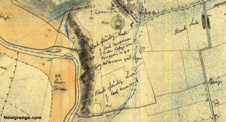 Knowth Mound referred to as a Moat (top of map), date of map 1837
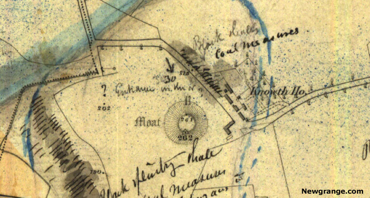 Close up of Knowth with a handwritten note showing one entrance, date of map 1837.
The Ordnance Survey Maps of Ireland in the 1830s
The nationwide Ordnance Survey of Ireland was one of the most ambitious mapping projects of the nineteenth century. Begun in the 1820s and carried out intensively during the 1830s, it produced the first detailed government survey of the whole island. The work was undertaken at a scale of six inches to one mile, a level of detail that had never before been applied to an entire country.
The survey was originally intended to support a fairer system of land valuation and taxation, but its importance soon went far beyond administration. The maps recorded roads, rivers, fields, houses, churches, graveyards, mills, townlands, parish boundaries and ancient monuments. They captured Ireland on the eve of the Great Famine and remain an essential source for historians, archaeologists, genealogists and local researchers.
The Irish survey was directed by Major General Thomas Colby of the Ordnance Survey, while Thomas Larcom played a major role in organising the work in Ireland. Teams of Royal Engineers, surveyors and draughtsmen travelled throughout the country, measuring the landscape with remarkable precision for the period.
The first edition six-inch maps were surveyed from the late 1820s through the 1830s and completed nationally by 1846. Ireland became the first country in the world to be mapped entirely at this detailed scale. The resulting maps provide a remarkably accurate picture of the pre-Famine landscape.
Townlands, Place Names and Local Knowledge
One of the most valuable aspects of the survey was its careful recording of townland names. Ireland's townlands are ancient local divisions, many with names that preserve early Irish language, landscape features, ownership traditions and folklore. Standardising these names for printed maps was a major task.
Scholars such as John O'Donovan and Eugene O'Curry were employed to investigate Irish place names, consult older manuscripts and gather local knowledge. Their work helped preserve many names that might otherwise have been lost or altered beyond recognition.
The Ordnance Survey Letters and Memoirs
The mapping project also produced written records. The Ordnance Survey Letters, particularly those written by John O'Donovan, contain observations about place names, churches, castles, monasteries, ancient monuments and local traditions. Today they remain one of the most important sources for the study of Irish local history.
There was also a plan to publish detailed Ordnance Survey Memoirs for every parish in Ireland. These memoirs were intended to accompany the maps and provide descriptions of local history, economy, population, customs, antiquities and natural features. The project began in the 1830s but was abandoned in 1840 because of its growing cost and complexity.
Although incomplete, the surviving memoirs are among the richest records of life in Ireland before the Great Famine.
Recording Ancient Monuments
The first edition maps are especially important for archaeology. They recorded many ancient monuments before later agricultural improvement, quarrying, road construction and modern development altered the landscape.
Surveyors used the terminology available to them at the time. Monuments were commonly labelled as raths, forts, moats, mounds, tumuli, cairns, cromlechs or stone circles. These descriptions often reflected contemporary understanding rather than modern archaeological classifications.
The maps therefore provide valuable evidence not only for the monuments themselves but also for how nineteenth-century antiquarians interpreted Ireland's ancient past.
Newgrange and Knowth on the 1837 Maps
The first edition Ordnance Survey maps of the Boyne Valley area, surveyed in 1837, provide an interesting example of this evolving understanding. Both Newgrange and Knowth were labelled as "Moats", a term commonly used at the time for large artificial mounds whose original purpose was uncertain.
On later copies of the map, a handwritten amendment changed the description of Newgrange from "Moat" to "Tumulus". This alteration reflects the growing recognition among antiquarians that Newgrange was a prehistoric burial monument rather than a medieval earthwork.
Knowth, whose passages remained concealed beneath the mound and were not excavated until the twentieth century, continued to be described as a moat. The differing labels illustrate how archaeological knowledge developed during the nineteenth century and how that changing understanding was reflected on official maps.
A Snapshot Before the Great Famine
The timing of the survey gives it exceptional historical value. Much of the fieldwork was completed in the 1830s, only a few years before the Great Famine transformed Ireland's population and landscape.
The maps preserve a record of roads, houses, mills, churches, field systems and settlements that in many cases disappeared or changed dramatically after the famine years. For genealogists and local historians, they provide an invaluable window into pre-Famine Ireland.
The Ordnance Survey maps of Ireland remain one of the greatest achievements of nineteenth-century cartography. Created for practical administrative purposes, they have become an irreplaceable historical resource.