
Newgrange from the air
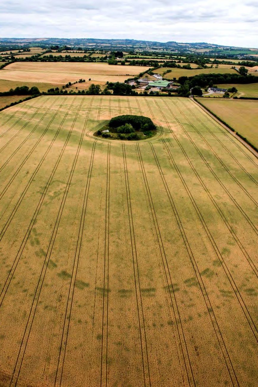 Interim report, December 2018. PDF, 146 pages, 9.4 MB.
In the dry weeks of June and July 2018 the floodplain below Newgrange could be read from the air. Wheat and pasture whitened, and the filled ditches and post-holes under them stayed dark or green.
Anthony Murphy and Ken Williams saw the first of the new enclosures with a drone, in the wheat immediately south of Newgrange Farm. The pattern drew attention well beyond County Meath. The National Monuments Service followed in July and August, flying with the Air Corps, and by December Tom Condit and Mark Keegan had written an interim account of the season. John Lalor took the oblique photographs. Mark Keegan did the mapping. Michael MacDonagh, Chief Archaeologist, signed the foreword.
The report was issued so the sites would be on record before a fuller publication. That publication has not appeared. The file linked here is the web version, and the photographs in it were reduced so it would download. A shorter telling of the same season came out in Heritage Ireland the following spring.
The ground they flew is the view from the entrance of the passage tomb, just over 61 m (200 feet) above the river. The Boyne closes it on the south, the ridge on the north, a townland boundary on the east and rising terraces on the west. Condit and Keegan call that block of land a geomorphological island. It is the middle of the bend.
Michael J. O'Kelly and Claire O'Kelly had walked it during the excavations of 1962 to 1975. Claire's map in the illustrated guide of 1978, still using the old letter names, marks Site P, the henge and mound at Site A, the mound of Site B, the low mounds A1 and B1, a possible tomb at Site U and the standing stone Site C. Nearer the great mound, Sites K, L and Z had been dug. LiDAR and geophysics by Steve Davis, Kevin Barton and Joe Fenwick had since picked up some of the low banks. The drought supplied the timber, which those surveys had only partly seen.
Reading the fields
A buried ditch holds moisture after the soil around it has dried, so the crop above it stays green when the rest of the field has gone pale. A buried wall or a band of stone does the opposite, and the crop there fails first. The July photographs catch that difference on a few days. In an ordinary summer there is nothing on the ground to follow.
Bluesky International had already flown vertical cover in late June. Keegan laid Lalor's oblique frames onto those photographs, the Ordnance Survey and the LiDAR, until a mark in a tilted picture had a measurement and a grid reference. The team then took a GPS onto the farms and stood on the lines. Almost every site in the report is private land, in crop or in grass, and the text is plain about that. There is no access without the owner's leave. From the ground most of the new monuments cannot be seen. The view the authors recommend to a visitor is the one from the tomb, out over the terraces to the Boyne.
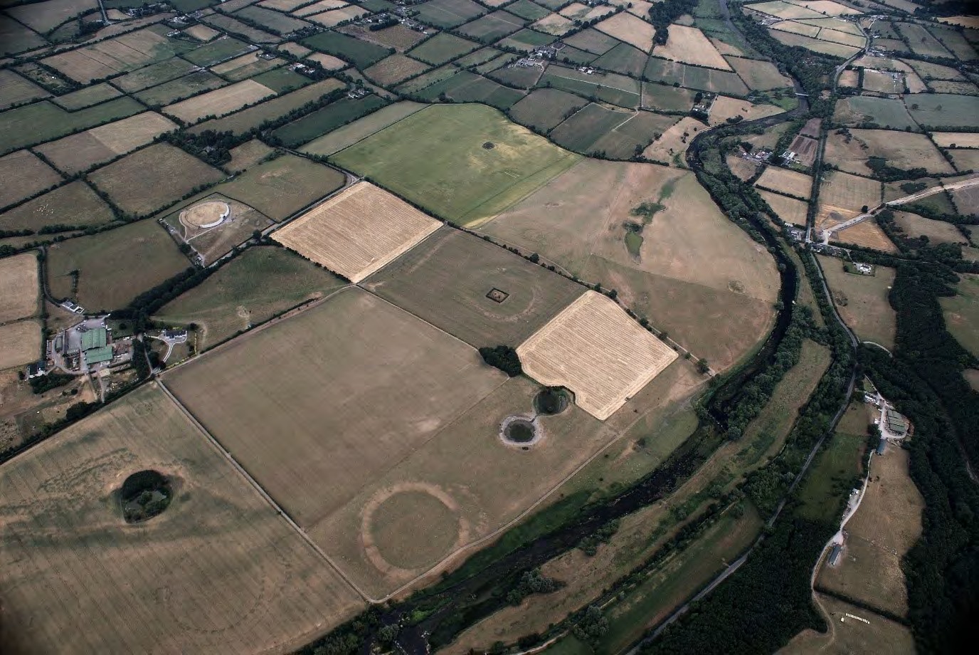 The floodplain at Newgrange from the south-west during the 2018 survey.
The wheat field south of the farm
The field that started the summer lies on the lowest terrace, about 48 m (157 feet) back from the Boyne. Murphy and Williams found the enclosure there in early July. Condit and Keegan call it the Geometric Henge, for the concentric rings and the lines that run between them. Others had already been calling it Dronehenge. The entrance of Newgrange is about 655 m (2,149 feet) to the north-east, and Newgrange Farm, the Redhouse farm, stands at the top of the field. The cover photograph looks that way, north across the wheat.
The figure measures 154 m (505 feet) from north to south and 143 m (469 feet) from east to west. The western arc is flattened, and a rectangular enclosure is built into that side. On the south-east an annexe of ditch segments bows outward, in the same manner as the annexes at Site A and Site B. It seems to have been an entrance. Three rings sit one inside another, and the authors take them as a single design. There is an outer ring of post-holes, a middle ring of post-holes and an inner enclosure of double segmented ditches. Those short, even ditch segments, repeated at the Univallate Henge next to it, are not known from any other ceremonial enclosure in Ireland.
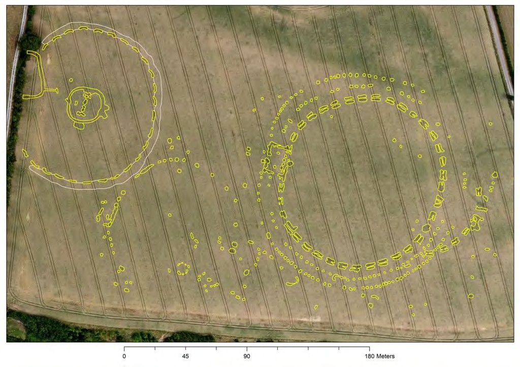 The Cropmarks Field, with the cropmarks drawn on. Yellow traces the Geometric Henge, its rings of posts and its broken ditches. The white circuit is a neighbouring henge in the same field.
The field holds more than the one circle that made the news. The Univallate Henge and the Hidden Henge stand with it, and so do a four-poster of large pits, a hook-shaped enclosure and dumbbell settings that look like rows of heavy posts in a trench. At least three long enclosures may be mortuary enclosures, a form well known in Britain and scarcely recorded in Ireland. A great palisade leaves this ground and runs on. Where it can be followed, an inner bank and palisade form the core, with two further palisades outside them, evenly spaced. Condit and Keegan think it may have continued around the ridge under the passage tomb, and that its purpose was to decide who went up.
Beside Site B
East of that group, in pasture rather than wheat, a second cluster sits on the lowest terrace beside Site B. The mound is conical and close to the water, and the river is known to come round its foot when the Boyne is high. The report treats it, as Claire O'Kelly did, as likely to cover a passage tomb. No chamber has been seen.
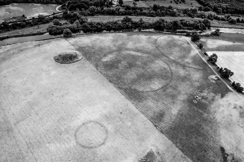 Henge Complex 2 from the north-east. Site B is the mound at the left. The dark rings in the grass are the ditches of the enclosures beside it.
Two large henges accompany the mound, alike enough that the authors take them as one idea carried out twice. Each has a broad bank and an outer ditch, and they come within 12 m (39 feet) of each other. The ring by the river is about 160 m (525 feet) across. The other, to the north-east, is about 120 m (394 feet). A smaller circle lies about 100 m (328 feet) further north-east again, a broad ditch with the trace of an outer bank. On a walk through the field almost none of this shows. The drought is what darkened the ditches.
Stephen Davis and Knut Rassmann, working later from these photographs and the LiDAR, measured the larger ring at an internal diameter of 154 m (505 feet) and could not make out a bank. Their 2021 study and this interim report are looking at the same marks and not quite agreeing what the marks are. The 2010 landscapes survey had already picked up the low oval of Site B1, off-centre in its own enclosure, before the outer ditch appeared in the grass.
After the tombs
Condit and Keegan place most of the new cropmarks in the later Neolithic, some centuries after the stone tombs of Newgrange, Knowth and Dowth. The posts imply timber buildings, enclosures and gatherings on a scale the floodplain had not shown. They take the change of material as a change in what the bend was being used for. They leave the sequence open. The commentary, they say, is somewhere to start, and it would be premature to be certain which monument came first. Pits in particular may be older than the tombs, of the same time, or later.
One monument was already partly known. In 2015 Joanna Leigh's survey found a large rectangle of pits south of the tomb. Geraldine Stout cut a section of it in 2018 for the Royal Irish Academy. The aerial photographs carried that rectangle much further. It is straight-sided and very large, and the report classes it as a hybrid cursus. The cropmarks give the plan. What stood on the posts is still to be pictured.
The four-poster is set beside Barry Hartwell's excavation at Ballynahatty in County Down and beside a similar setting found at Knowth. The Newgrange example is the larger of them. The authors take that as the same habit of enlargement that sets the great Boyne tombs apart from passage tombs elsewhere.
Still an interim
MacDonagh wrote that the Service meant to bring landowners and researchers together in 2019 and agree what should be done next. The images were still being catalogued when the report went out. The opinions in it are the authors' own, and they warn that a final text might read differently once more was known. No final report has been published.
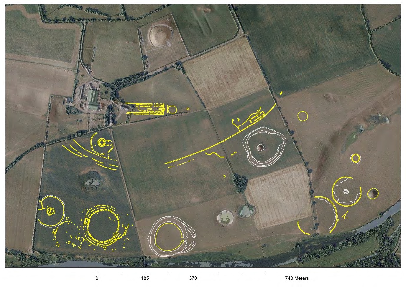 The floodplain with the 2018 cropmarks drawn on. Newgrange Farm is at the left and the Boyne runs along the lower edge. Mapping by the National Monuments Service, on a Bluesky photograph.
Taken together, the new sites and the new detail on old ones put the henges in two groups along the river, and both groups also follow a broad old channel across the floodplain. The palisade, if it does ring the ridge, was there to set the tomb apart from the fields below it. What the season did not give is a date for any of it.
Contents
- Introduction.
- Part 1. Background.
- Brú na Bóinne, settlement and ritual.
- The floodplain at Newgrange.
- Aerial archaeological survey.
- 2018 aerial reconnaissance over Brú na Bóinne.
- GIS, mapping, recording, illustrating and archiving.
- Newgrange floodplain location map.
- Part 2. The Cropmarks Field.
- Site No. 1. The Four-Poster enclosure.
- Site No. 2. The Four-Poster outer enclosure.
- Site No. 3. The Great Palisade.
- Site No. 4. The Univallate Henge.
- Site No. 5. The Geometric Henge.
- Site No. 6. The Hidden Henge.
- Site No. 7. The Hook Enclosure.
- Site No. 8. The Double Dumbbell feature.
- Sites No. 9. Miscellaneous features in the Cropmarks Field.
- Part 3. The central and eastern floodplain.
- Site No. 3. The continuation of the Great Palisade.
- Site No. 10. Site P, henge.
- Henge Complex 1.
- Site No. 11. Site A, henge.
- Site No. 12. Site A1, enclosure.
- Site No. 13. The oblong enclosure.
- Sites No. 14. Miscellaneous features.
- Site No. 15. Linear Feature 1.
- Site No. 16. The Great Rectangular Palisade Enclosure.
- Site No. 17. Linear Feature 2.
- Site No. 18. The Cursus Field.
- Sites No. 19. Miscellaneous cropmarks.
- Henge Complex 2.
- Site No. 20. Site B, the Small Enclosure.
- Site No. 21. Site B, the Small Henge.
- Site No. 22. Site B, the Riverside Henge.
- Discussion and summary.
- Bibliography.
Read or download the PDF of the December 2018 interim report (146 pages, 9.4 MB).